 UAE BARQ برق الإمارات – نبضك
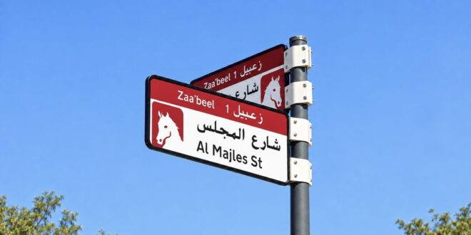
The Supreme Committee for Urban Planning, in coordination with Dubai’s Roads and Transport Authority (RTA) and Dubai Municipality, has launched a new visual identity and enhanced addressing system for areas across the Emirate of Dubai.
The initiative includes the installation and replacement of area identification signs, internal street name signs, and house number plates, featuring unified designs and colours that reflect the geographic characteristics of each area.
Developed through a specialist consultant in wayfinding and addressing design, the new system will help facilitate the identification of locations and improve accessibility, while enhancing the visual appeal of streets, residential neighbourhoods, and commercial districts.
The launch forms part of efforts to establish an integrated and clear addressing system that keeps pace with Dubai’s rapid urban development. Going beyond its traditional wayfinding role, the new system is designed to become an integral component of the visual identity of Dubai’s areas, while contributing to the enhancement of streets and road facilities and highlighting the geographic and urban characteristics that distinguish communities across the emirate.
The implementation plan covers 186 areas distributed across 19 sectors throughout Dubai, under a phased programme that will begin in the fourth quarter of 2026 and continue through 2030. The first phase of the project will commence this year and will include the installation and replacement of more than 2,000 signs across five areas: Za’abeel 1, Za’abeel 2, Nad Al Sheba, Al Khawaneej 1, and Nazwa, in accordance with the approved visual identity for each area.
The new visual identity incorporates five colours specifically designed to reflect the character and geographic features of Dubai’s various areas, providing each with a distinctive visual signature while maintaining a clear and consistent addressing system across the emirate.
The selected colours have been carefully aligned with the nature of each area. For example, blue represents areas located close to the sea, while gold symbolises areas characterised by a desert environment, reflecting the diversity of Dubai’s landscapes and urban fabric.
The new identity encompasses sector and area identification signs, internal street name signs, and house number plates, with designs and colour schemes developed to achieve visual integration across all components of the addressing system. Future project deliverables will extend the identity to bus stops, smart applications, and area map boards. In addition, QR codes will be introduced to provide information about sectors and areas, the meanings behind street and area names, points of interest, and other relevant location-related content.
In coordination with Dubai Municipality, RTA has established a set of criteria to determine implementation priorities across the emirate. These include urban growth and population density, the vibrancy and centrality of areas, the presence of residential and tourist attractions, and the proportion of streets that have not yet been formally addressed. This approach ensures that project implementation aligns with urban development trends and the needs of residents across Dubai.
As part of the continued rollout of the new addressing identity, RTA has coordinated with Dubai Municipality to complete and approve the final designs for house number plates. These plates will feature each property’s Makani number and corresponding QR Code, with colours harmonised with those of the new addressing signs to enhance visual integration, reinforce a unified identity, and further facilitate location identification.